The construction of a home begins long before the work itself. Increasingly, individuals and self-builders want to better understand the conditions of a plot before making decisions, but much of the available geological information has traditionally been intended for technical profiles.
For decades, geotechnics has been an area closely linked to fieldwork, technical reports, and professional interpretation of subsurface data. This part remains essential, especially when a project is to reach the construction phase. However, the digital transformation of the sector is introducing a preliminary layer of information that is more understandable for the general public: knowing what type of soil may be in an area, what geological risks are associated with it, or what cartographic information exists about that environment.
The leap is not just about seeing geological maps online, but about being able to start with a specific address and understand what the ground is saying.
A significant part of this change comes from leveraging public data. Geological and cartographic organizations have been publishing maps, layers, and databases on geology, lithology, hydrogeology, and seismicity over the years. These resources already existed, but they were often aimed at professionals accustomed to reading technical cartography. The current challenge is to translate this knowledge into tools that can also be understood by someone who wants to buy, build, or value a plot.
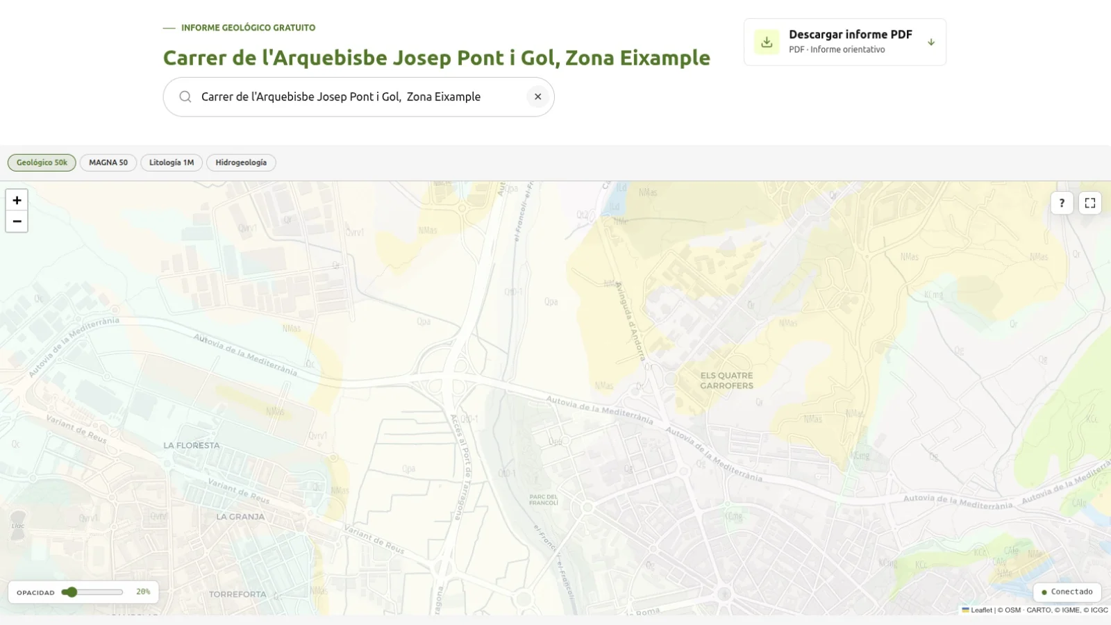
It is in this context that viewers like Estudio Geotécnico Pro emerge, which brings together geological cartography, MAGNA maps, lithological and hydrogeological information, and data from territorial organizations to offer an initial reading of the ground in more accessible language. Instead of forcing the user to navigate directly through complex cartographic layers, the tool incorporates a search by address: a person can enter the location they want to consult, locate their plot, or select a point on the map and see indicative information related to the type of soil, expected stratigraphy, geological risks, or seismicity of the area.
The value of these types of tools is particularly clear in self-building processes. Before buying land or commissioning the initial work for a project, many people want to understand if the plot is in an area with more or less favorable materials, if there are known geological constraints, or if it is advisable to pay attention to certain foundation aspects. Having an initial reading does not resolve these issues, but it helps to formulate them better.
Public data can expand the citizen's initial knowledge, provided it is understood as guidance and not as a definitive conclusion.
The viewer allows anyone to enter a specific address and instantly obtain indicative geological information about that point: soil type, lithology, hydrogeological constraints, and the seismicity level of the area. Without needing to know technical cartography, the user can locate their plot on the map and read, in understandable language, the characteristics of the ground beneath.
This distinction is key. A geotechnical viewer can display useful information, but it cannot replace the on-site surveys, tests, calculations, and specific interpretation required for a construction project. As a work progresses towards a technical or administrative phase, this information must be supplemented with a geotechnical study prepared by professionals.
The trend, therefore, is not to replace specialized reports, but to open a preliminary stage of more transparent consultation. Just as other sectors have incorporated comparison tools, simulators, or interactive maps, geotechnics is beginning to make part of its contextual knowledge accessible to a broader audience. This can improve communication between owners, architects, engineers, and specialized companies.
There is also a territorial and linguistic dimension. When these tools are presented in different languages, they make technical information more accessible in various contexts. In a country with diverse regulations, cartography, and administrations, this adaptation can be as important as the visualization of the data itself.
The ground will continue to require study, verification, and professional judgment. However, the way to reach this point is changing. Before digging a trench or commissioning a reconnaissance campaign, it is increasingly common to look at the map, consult the available data, and start the project with a clearer idea of the ground beneath one's feet.